California's National Park Legacy
California's relationship with national parks is foundational to the concept itself. Yosemite Valley was the first piece of land set aside by the federal government specifically for public recreation and preservation, in 1864 — a decision that planted the seed from which the entire national park system grew.
The nine national parks within California's borders collectively represent one of the most extraordinary concentrations of protected natural landscapes anywhere on Earth. From the Pacific coastline to the Sierra Nevada, from the Mojave Desert to the northern rainforests, the range of ecosystems and geological formations preserved within these parks is simply staggering.
John Muir, the Scottish-American naturalist who became California's first great wilderness advocate, spent much of his career exploring and writing about California's wild places — particularly the Sierra Nevada range he called the "Range of Light." Muir's passionate advocacy, expressed through his writings and through his founding of the Sierra Club in 1892, was instrumental in persuading Congress to establish Yosemite as a national park in 1890. The tradition of environmental advocacy that Muir established has continued in California for 130 years, and the state's exceptional natural heritage is the living proof of what that advocacy has protected.
Yosemite National Park: The Crown Jewel
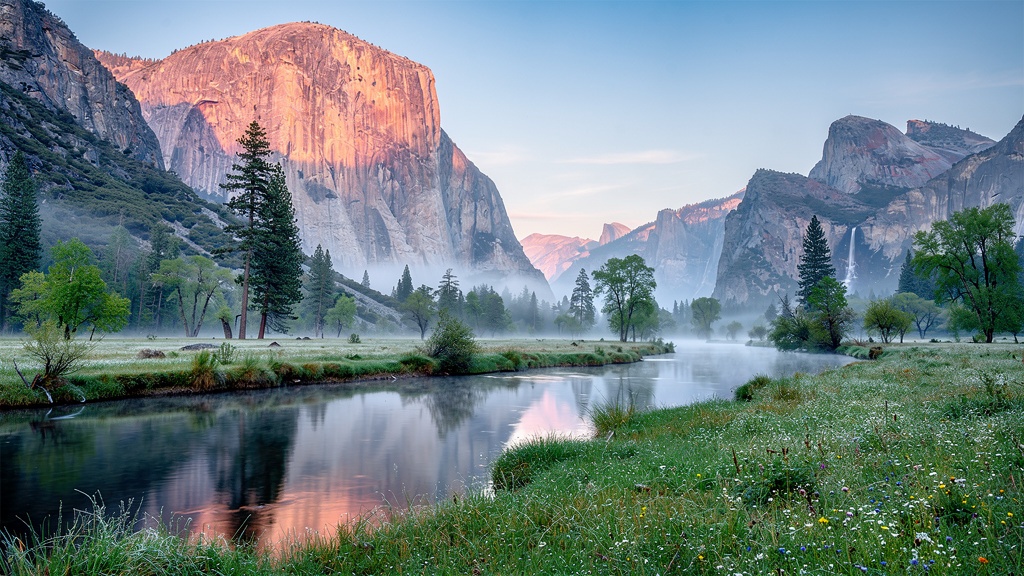
Yosemite National Park is one of the great natural wonders of the world — a place of such overwhelming scale and beauty that first-time visitors consistently report being moved to tears at their first sight of Yosemite Valley. The park encompasses 1,169 square miles in the Sierra Nevada mountains of central California, and within those boundaries contains landscapes of extraordinary geological and biological diversity.
The glacially carved Yosemite Valley itself — seven miles long, roughly a mile wide, and walled on both sides by granite cliffs rising up to 4,000 feet from the valley floor — is the park's most visited section. From the Tunnel View lookout at the valley's eastern entrance, visitors see one of the most compositionally perfect landscapes on Earth: El Capitan (the largest exposed granite monolith in the world at 3,000 feet) on the left, Half Dome (the park's iconic split-rock formation) at the center distance, and Bridalveil Fall cascading 620 feet on the right, all framed by the valley's meadows and the Merced River reflecting the scene.
Yosemite's waterfalls are among its most dramatic seasonal features. Yosemite Falls — the tallest waterfall in North America at 2,425 feet total — flows most powerfully in May and June when snowmelt is at its peak. Bridalveil Fall flows year-round. Vernal Fall (318 feet) and Nevada Fall (594 feet) on the Mist Trail east of the valley offer thrilling encounters with spray and power during the spring and early summer.
El Capitan holds a special place in the hearts of rock climbers worldwide. The 3,000-foot vertical granite face was first climbed in 1958, when Warren Harding and his team took 47 days to complete the first ascent using siege tactics. Today, elite climbers complete routes on El Cap in a matter of hours; in 2017, Alex Honnold free-soloed the Freerider route (approximately 3,000 feet of technical climbing without ropes or protection) in 3 hours and 56 minutes — an achievement that the New York Times called "the greatest athletic achievement in history." A pair of binoculars is useful for watching climbers on El Cap's wall during summer days.
The Mariposa Grove, in the park's southwestern corner, contains approximately 500 mature giant sequoias, including the famous Grizzly Giant — at roughly 2,700 years old, one of the oldest living things on Earth. The grove has been restored to its natural state over the past decade after decades of road and infrastructure impacts, and is now accessible only on foot or shuttle, ensuring a quiet and reverential experience in one of the most remarkable forests on the planet.
Yosemite's high country — accessible via the Tioga Road (Highway 120) from late May through October — offers an entirely different experience from the valley floor: a world of open granite slabs, alpine meadows, pristine glacial lakes, and 360-degree Sierra views above the treeline. Tuolumne Meadows, the largest subalpine meadow in the Sierra Nevada (and one of the best places in the park to see wildlife), is the starting point for some of Yosemite's finest backcountry hiking.
🏕 Yosemite Essential Information
- Entry fee: $35/vehicle, $20/person (or America the Beautiful Pass)
- Reservations: Required for day visitors May 22–Sep 7; book at recreation.gov
- Best months: September–October (fewer crowds, warm days, beautiful light)
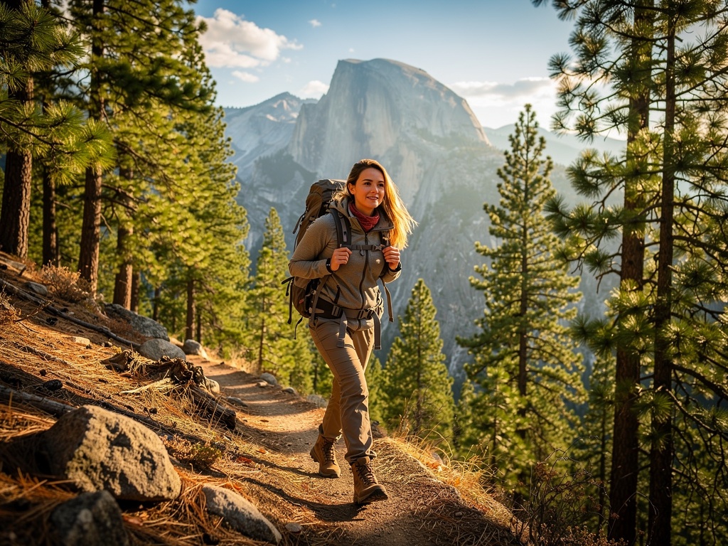
- Top hikes: Mist Trail to Vernal Fall (3 miles RT); Half Dome (16 miles RT, permit required); Mirror Lake Loop (5 miles); Sentinel Dome (2.2 miles)
- Accommodation: Book Ahwahnee Hotel and valley campgrounds 6–12 months ahead
- Wildlife: Black bears are active; use bear boxes for all food; never feed wildlife
Sequoia & Kings Canyon National Parks
Adjacent and jointly administered by the National Park Service, Sequoia and Kings Canyon National Parks together encompass 1,353 square miles of the southern Sierra Nevada — a landscape that includes the five largest trees in the world, the deepest canyon in North America, and the highest peak in the contiguous United States.
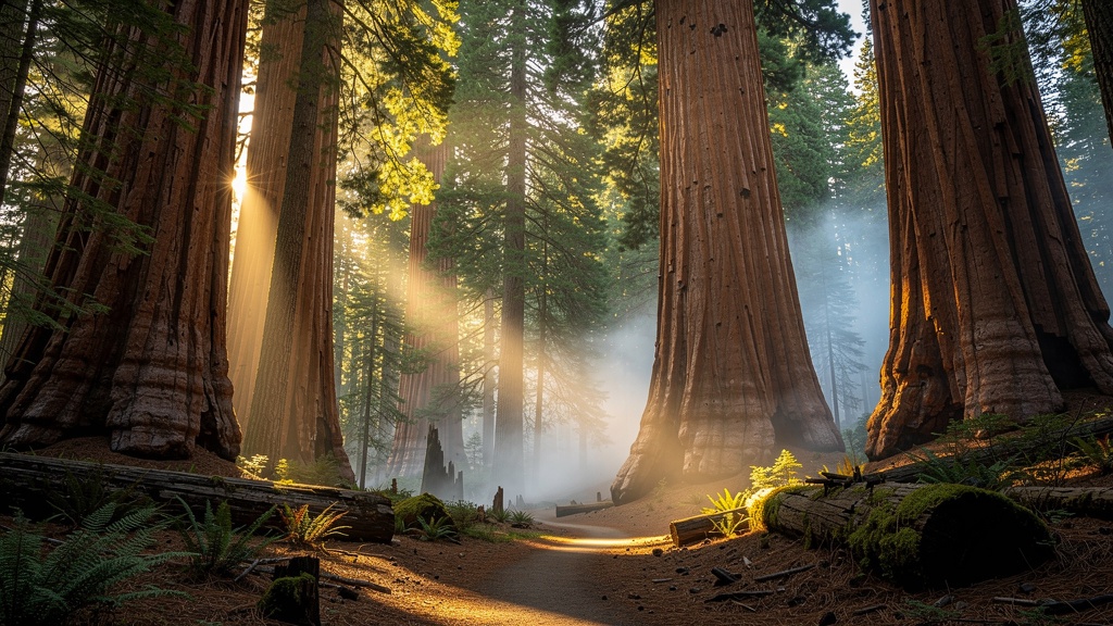
The giant sequoias (Sequoiadendron giganteum) that give Sequoia National Park its name are the largest living things on Earth by volume — not the tallest (that distinction belongs to the coastal redwoods of Northern California) nor the widest, but the most massive. General Sherman Tree, in the Giant Forest of Sequoia National Park, has a calculated volume of 52,508 cubic feet, making it the largest living organism on Earth by wood volume. The tree is approximately 2,200 years old, 274 feet tall, and 36 feet in diameter at its base. Standing beside it — in a grove of dozens of sequoias of similar antiquity and scale — is one of the most overwhelming natural experiences available in California.
Kings Canyon, administered jointly with Sequoia, contains Kings Canyon itself — carved by the Kings River to a depth of 8,200 feet from its rim to the river below, making it the deepest canyon in North America (deeper than the Grand Canyon when measured from rim to river). The canyon's road, Highway 180, descends steeply into the canyon floor and is accessible only from late May through early November, when snow conditions permit. The canyon bottom, where the Kings River roars through granite walls and cottonwood trees provide shade, is one of the most dramatic river environments in the Sierra Nevada.
Mount Whitney (14,505 feet), the highest point in the contiguous United States, sits on the eastern boundary of Sequoia National Park. The Whitney Portal Trail, beginning in Lone Pine at the base of the eastern Sierra escarpment, is one of the most popular long-distance day hikes in the United States — a 22-mile round trip that gains nearly 6,000 feet of elevation and requires significant preparation, permits (obtained by lottery), and good physical condition.
🌲 Sequoia & Kings Canyon Quick Tips
- General Sherman Tree: accessible year-round via an accessible trail from Giant Forest Museum
- Crystal Cave: the only undeveloped wild cave in the park system; guided tours available May–November (purchase tickets online in advance)
- Moro Rock: a 350-step staircase carved into a granite dome offering 360-degree views; close to Generals Highway
- Roads to higher elevations (Mineral King, Kings Canyon Road) are closed November–May; always check road conditions
Death Valley National Park: Beautiful Extremes
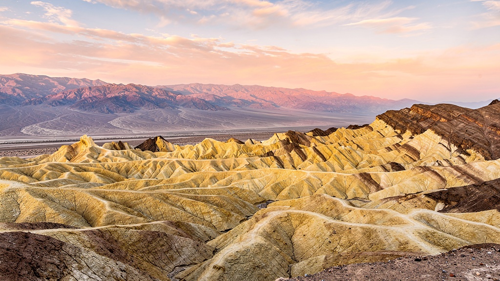
Death Valley National Park is a place of superlatives: the hottest air temperature ever recorded on Earth (134°F / 56.7°C on July 10, 1913, at Furnace Creek), the lowest point in North America (Badwater Basin, 282 feet below sea level), and the largest national park in the continental United States (5,270 square miles). Yet despite its forbidding reputation, Death Valley is also one of the most visually dramatic and ecologically fascinating places in California.
The valley's geological history is written in layers of extraordinary color. The landscape was formed by a combination of tectonic forces (the valley sits in a graben — a block of earth that has subsided between parallel fault lines) and subsequent erosion by water and wind. The result is a palette of reds, oranges, yellows, and whites that shift dramatically with the angle and quality of light, making Death Valley a photographer's paradise, particularly at dawn and dusk.
Zabriskie Point — an elevated overlook above the eroded badlands of the Amargosa Range — offers what many photographers consider the finest sunrise view in the park: a sea of golden, folded ridges catching the first light and casting shadows of extraordinary depth and contrast. The similarly dramatic Dante's View, 5,476 feet above the valley floor, provides a panoramic perspective from which Badwater Basin is visible 11,000 feet below, with Mount Whitney visible on the clear horizon to the west.
Death Valley is not as lifeless as its name implies. The valley contains over 1,000 species of plants (some found nowhere else on Earth), at least 50 species of mammals, and more than 300 bird species. The pupfish of the Cottonball Marsh — tiny, remarkably hardy fish that have survived in the hypersaline waters of Death Valley for thousands of years since the last glacial period when the valley contained a vast freshwater lake — are one of the most extraordinary examples of evolutionary adaptation in North America.
The Mesquite Flat Sand Dunes, rising to 100 feet at the north end of the valley, are among the most accessible and photographically rewarding dune systems in California. The dunes are particularly magical in late afternoon light and under a full moon, when their curves and shadows create abstract compositions of great beauty. Sunrise and early morning are best for seeing animal tracks preserved in the sand before human foot traffic erases them.
The winter wildflower super-blooms that occasionally transform Death Valley from a landscape of sand and rock into a carpet of gold poppies, purple phacelia, and white evening primrose are among California's most spectacular natural events. They occur when fall and winter rainfall totals exceed normal levels — roughly once every 10 years for a major bloom event. When they do occur, they draw hundreds of thousands of visitors to the valley, and the visual contrast between the flower-covered valley floor and the stark surrounding mountains is almost surreal.
⚠️ Death Valley Safety — Read Before Visiting
- Summer heat: Avoid visiting June–August; temperatures regularly exceed 120°F. If you must visit in summer, limit outdoor activity to 6–9 AM and after 6 PM
- Water: Carry at least 1 gallon of water per person per day for hiking; 2 gallons in summer
- Vehicle: Ensure your car's coolant and oil are at proper levels; have a full tank before entering remote areas
- Cell service: Very limited within the park; download offline maps and inform someone of your itinerary
- Best months: November–March for comfortable temperatures (50–70°F days)
Joshua Tree National Park: Where Two Deserts Meet
Joshua Tree National Park, straddling the boundary between the Mojave Desert to the north and the Colorado Desert (part of the Sonoran) to the south, is one of California's most ecologically fascinating and visually distinctive national parks. The park is named for the Joshua tree (Yucca brevifolia) — a remarkably charismatic tree-like yucca that grows only in the Mojave Desert and whose twisted, outstretched branches give it an otherworldly appearance that has made it one of the most photographed plants in California.
The park's landscape is dominated by extraordinary granite rock formations — massive piles of smooth, rounded boulders sculpted by millions of years of weathering into formations of great visual and geological interest. Skull Rock, Cap Rock, Arch Rock, and Jumbo Rocks are among the most visited formations, scattered across the park's 794,000 acres in clusters that create a geological wonderland perfectly suited to both rock climbing (the park contains over 8,000 documented climbing routes, making it one of the premier climbing destinations in North America) and to photography.
Joshua Tree has become, over the past two decades, almost as famous for its cultural associations as for its natural beauty. U2's 1987 album The Joshua Tree — one of the best-selling rock albums of all time — was named for the park's signature plant and helped introduce millions of people worldwide to the landscape's austere beauty. The park has also become a center of California's arts and music communities, with the nearby towns of Joshua Tree and Twentynine Palms home to a growing community of artists, musicians, and makers who are drawn by the landscape's stark beauty, affordable real estate, and proximity to the Los Angeles creative scene (approximately 2.5 hours distant).
Dark sky enthusiasts should note that Joshua Tree is one of the finest dark sky locations accessible from a major metropolitan area in the United States. On clear nights, far from the light pollution of Los Angeles and Palm Springs, the Milky Way is visible with the naked eye, and the combination of the park's dramatic rock formations in the foreground and the star-filled desert sky above creates one of the most otherworldly nighttime experiences available in California. The annual Joshua Tree Night Sky Festival celebrates this resource with lectures, guided viewing, and astrophotography workshops.
Redwood National & State Parks: The Cathedral Trees
The coast redwood (Sequoia sempervirens) is the tallest living organism on Earth. The tallest known individual, Hyperion, stands 380 feet tall — approximately the height of a 37-story building — and grows in a remote section of Redwood National Park in Northern California. The location of Hyperion is intentionally kept secret by park managers to protect it from impact, but the experience of walking through any of the park's old-growth redwood groves is one of profound, almost spiritual awe.
Coast redwoods evolved 20 million years ago and once stretched across much of the Northern Hemisphere. Their current range, restricted to a narrow strip of fog-irrigated coastline from Big Sur in the south to southern Oregon in the north, represents less than 5% of their original territory. Logging between 1850 and 1960 eliminated roughly 95% of the original old-growth redwood forests; the surviving groves in Redwood National and State Parks represent an irreplaceable ecological treasury.
The parks offer a variety of redwood experiences for visitors of different abilities and interests. The Lady Bird Johnson Grove, accessible via a 1.4-mile loop trail, was dedicated by President Nixon in 1969 and offers one of the most accessible and photogenic old-growth redwood experiences in the parks. The Tall Trees Grove requires a permit and a moderately strenuous 8-mile round-trip hike to reach — but rewards those who make the effort with encounters with individual trees of extraordinary size in a grove of particular quality. The Fern Canyon, in Prairie Creek Redwoods State Park, is a 50-foot-deep chasm whose walls are entirely covered with five-finger ferns, creating one of the most visually extraordinary natural environments in California — and a location used in Steven Spielberg's The Lost World: Jurassic Park (1997).
Channel Islands National Park: California's Galápagos
The Channel Islands National Park — encompassing five of the eight Channel Islands off the Southern California coast, plus the surrounding one nautical mile of ocean — is California's most isolated and ecologically extraordinary national park, and one of its least visited. Reached only by boat or plane from Ventura or Santa Barbara, the islands' geographic isolation has produced the same evolutionary effects that Darwin observed on the Galápagos: species found nowhere else on Earth, in a state of nature that has changed little since the last Ice Age.
The islands' endemic species include the island scrub-jay (found only on Santa Cruz Island — the largest of the five park islands at 96 square miles), the island fox (a miniature fox one-third the size of its mainland cousin), the island deer mouse, and dozens of endemic plant species. The surrounding ocean is a National Marine Sanctuary teeming with marine life: blue whales (the largest animals ever to have lived on Earth) feed in the Santa Barbara Channel during summer, and humpback, gray, and fin whales pass through seasonally. California sea lions, elephant seals, harbor seals, and dolphins are year-round residents.
Anacapa Island, the closest to the mainland (approximately 12 miles from Ventura), is most easily accessible for day visitors. The island offers excellent tide pooling, wildlife viewing, and hiking on its chalky bluffs, with outstanding views of the California coastline on clear days. Santa Cruz Island's Painted Cave — at 1,227 feet deep and 160 feet wide at its entrance, one of the world's largest sea caves — is accessible by kayak for experienced paddlers. Santa Rosa Island's Torrey Pine grove contains specimens of the world's rarest pine species, Pinus torreyana, growing in conditions essentially unchanged from the Pleistocene.
Pinnacles National Park: The Ancient Volcano
Pinnacles National Park, established as California's most recent national park designation in 2013 (it had been a national monument since 1908), is one of the most geologically unusual and ecologically significant parks in California. Located approximately 80 miles south of San Jose in the Salinas Valley hills, Pinnacles preserves the eroded remnant of an ancient volcano that erupted approximately 23 million years ago — and which, owing to the movement of tectonic plates along the San Andreas Fault, is now located 195 miles north of its original eruption point.
The park's dramatic rock spires, talus caves, and chaparral-covered canyon walls create a landscape unlike anything else in California, and provide habitat for the California condor — the largest bird in North America, with a 9.5-foot wingspan — which has been reintroduced to Pinnacles after near-extinction. California condors can be observed almost daily soaring on the thermals above the park's crags; the park is one of only two places in California (the other being Big Sur) where condors are reliably visible.
The Balconies Cave trail is the park's signature experience: a 2.4-mile route through talus caves formed by massive boulders wedged between the canyon walls, creating natural tunnels that require hikers to navigate with the aid of a flashlight. The caves are home to 13 species of bats — the highest diversity of bat species in any California park — and are closed during bat maternity season (April–July) to protect nesting colonies. The High Peaks Trail Loop, covering the park's most dramatic rock formations, provides excellent condor-spotting opportunities and panoramic views across the Salinas Valley.
Planning Your California National Parks Visit
Visiting California's national parks requires more advance planning than most visitors initially realize. Demand for park access has grown dramatically over the past decade, and the most popular parks — particularly Yosemite — now operate timed-entry reservation systems during peak seasons. Understanding the reservation systems, the seasonal considerations, and the logistical realities of park visits will significantly improve your experience.
🎫 The America the Beautiful Pass
At $80 per year, the America the Beautiful Annual Pass is the single best value in American travel. It provides entrance to all 400+ national park units, national forests, Bureau of Land Management recreation sites, and more — for the pass holder and up to three additional adults. For most visitors to California planning to visit even two national parks, the pass pays for itself. Senior passes (for U.S. citizens and permanent residents 62+) are available for $80 lifetime or $20 annual, and provide the same access.
📅 Reservation Systems
All reservations for national park facilities are made through Recreation.gov. Yosemite requires day-use reservations during peak season (late May–early September) and camping reservations up to 5 months in advance. Half Dome permits are obtained by lottery through Recreation.gov. Sequoia's Crystal Cave tours require advance tickets. Death Valley's Furnace Creek campground (the most popular in the park) fills months in advance. Plan for all major parks as if reservations are required — last-minute access is increasingly uncertain.
🌡 Seasonal Considerations
California's national parks are dramatically different across seasons. Yosemite's high country is inaccessible from November through May. Death Valley is best visited November–March and can be dangerous in summer. Joshua Tree is most comfortable October–May. Redwood's coast can be foggy and cool year-round but rarely inhospitable. The Channel Islands require boat reservations and are subject to weather cancellations from October through February. Always check park websites for current conditions and closures before traveling.
🥾 Essential Hiking Gear
For any California national park hiking, pack: a minimum of 2 liters of water per person (more in desert parks), high-SPF sunscreen and lip balm, a hat with a brim, moisture-wicking layers (temperatures can change dramatically with elevation), sturdy closed-toe shoes with ankle support, a paper map (cell service is unreliable in all parks), a headlamp with extra batteries, a basic first aid kit, emergency whistle, and high-energy snacks. For overnight trips, add a bear canister (required in most Sierra parks) and a filter for water sources.