Why California Is a Road-Tripper's Paradise
California possesses a rare geographic alchemy that turns every road trip into an epic: within a single state you can drive from surf-battered sea cliffs to glacier-carved mountain valleys, from ancient redwood cathedrals to shimmering desert salt flats, all linked by some of the world's most storied asphalt. No other American state packs such radical variety into every tank of gas.
The California road-trip tradition stretches back to the early twentieth century, when the state's boosters marketed Highway 1 and the Lincoln Highway as ribbons of democratic freedom — open to anyone with a motor car and a sense of wonder. Today that spirit endures: on any given weekend you will find vintage Airstream trailers parked at Big Sur bluffs, electric vehicles humming through the Mojave, and converted vans camped beside Sierra Nevada lakes, each occupant chasing the same intoxicating mixture of solitude, beauty, and forward motion.
Whether you have four days or four weeks, whether you crave salt air or desert heat, whether you're a first-timer or a seasoned wanderer returning for the twentieth time, California's road network has a route calibrated exactly to your appetite. This guide walks you through the state's greatest drives mile by mile, offers practical planning advice shaped by real seasonal conditions, and spotlights the hidden pull-offs, roadside diners, and wild camping spots that never make it into the glossy brochures.
Ready? The pavement is warm, the horizon is infinite, and the Golden State is waiting.
Highway 1 — The Pacific Coast Highway
Of the thousands of scenic drives in the United States, none captivates the imagination quite like California's Highway 1 — the Pacific Coast Highway. Running for approximately 659 miles from Dana Point in Orange County north to Leggett in Mendocino County, PCH strings together an almost unbroken necklace of beaches, headlands, fishing villages, and wilderness parks.
Southern PCH: Orange County to Santa Barbara
The southern gateway to PCH begins at Dana Point, a charming harbor town where you can watch surfers thread the break at Doheny State Beach. Heading north, Laguna Beach seduces with its art galleries and hidden coves — park the car and walk down the cliff-stairs to Victoria Beach, where a stone Pirate Tower rises from the sand like something from a fairy tale. Newport Beach offers a broader, more boisterous stretch of strand, famous for its ultra-wide bike path and the world's largest pleasure-craft harbor.
Continuing past Los Angeles, Malibu stretches for nearly 27 miles of shoreline, its famous Surfrider Beach a mecca for longboard surfers and celebrity spotters alike. North of Malibu, the Coast Highway ducks inland briefly before rejoining the water at Point Mugu State Park, where the Santa Monica Mountains tumble directly into the sea and the highway becomes noticeably more dramatic. Ventura's downtown farmers' market and the old Mission of San Buenaventura make an excellent pit stop, and Santa Barbara — the so-called "American Riviera" with its white-washed buildings and red-tile roofs — rewards an overnight stay.
Central PCH: San Luis Obispo County to Monterey
North of Santa Barbara the crowds thin and the landscape turns raw and magnificent. The rolling Gaviota coast, still largely undeveloped, gives way to Pismo Beach, whose sand dunes stretch inland for miles and host dune-buggy enthusiasts on summer weekends. The college town of San Luis Obispo — midpoint of the California coast — sits inland but rewards a short detour for its Thursday night farmers' market, the eccentric Bubblegum Alley, and proximity to Hearst Castle, William Randolph Hearst's gloriously excessive hilltop estate above San Simeon.
North of Cambria the highway begins its most legendary passage: the 90-mile corridor through Big Sur, addressed in full in the next section. Beyond Big Sur lies the Monterey Peninsula, home to the world-famous Monterey Bay Aquarium, the historic Cannery Row (immortalized by Steinbeck), the artsy village of Carmel-by-the-Sea, and the famous 17-Mile Drive through Pebble Beach's wind-sculpted cypress groves.
Northern PCH: Santa Cruz to Mendocino
From Santa Cruz — home of the iconic beach boardwalk and the pioneering university — PCH traces the quieter, more agricultural north coast. Half Moon Bay is famous for its pumpkin festival in October and for hosting the Mavericks surf competition, where professional big-wave riders challenge walls of water over 60 feet tall. Pacifica and Daly City mark the southern suburbs of San Francisco; the city itself must be navigated via the 19th Avenue corridor before Highway 1 resumes properly on the Marin Headlands.
North of San Francisco the highway passes through Point Reyes National Seashore, a fog-laced peninsula where dairy farms, tule elk, and grey whales co-exist in an untamed coastal wilderness. The small towns of Bodega Bay, Jenner, and Gualala each offer cosy inns and seafood shacks perched above the surf. The northern endpoint of the classic PCH experience is generally considered to be the Victorian village of Mendocino, whose dramatic headlands and art-gallery-lined Main Street make it one of the most photographed small towns in California.
PCH Driving Tips
- Direction: Drive south-to-north if possible — the ocean will be on your left (west) the entire way, giving passengers unobstructed cliff-and-sea views without the driver needing to crane their neck.
- Time budget: Allow a minimum of 5–7 days for the full length. Most visitors focus on the Monterey-to-Santa Barbara corridor and spend 3 nights.
- Fuel: Gas stations become sparse north of Cambria; fill up in San Luis Obispo and again in Big Sur's Gorda station (premium prices, but worth it).
- Cell service: Non-existent through much of Big Sur and the Mendocino coast. Download offline maps before departing.
- Landslide closures: Winter storms periodically close PCH through Big Sur. Check Caltrans QuickMap before setting out.
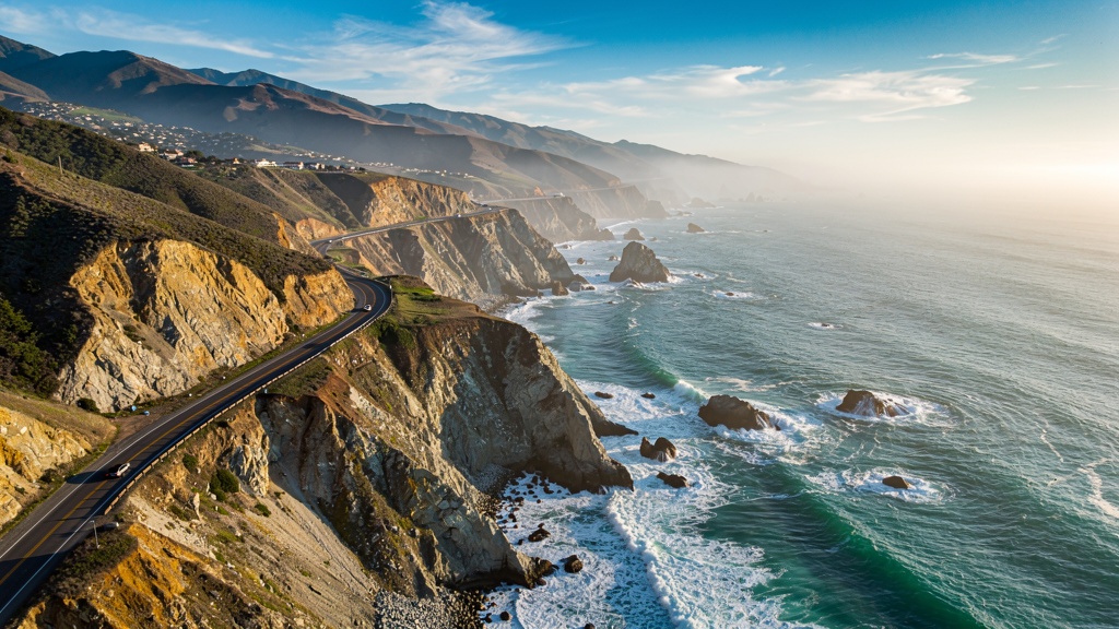
Big Sur: The Crown Jewel of the Pacific Coast
No road-trip destination in California generates more reverence — or more Instagram posts — than the 90-mile stretch of Highway 1 between Carmel and San Simeon known simply as Big Sur. Here the Santa Lucia Range drops precipitously into the Pacific, creating cliffs that in places rise 1,000 feet straight from the water, while the highway clings to their face with the audacity of a mountain goat.
The Landmarks of Big Sur
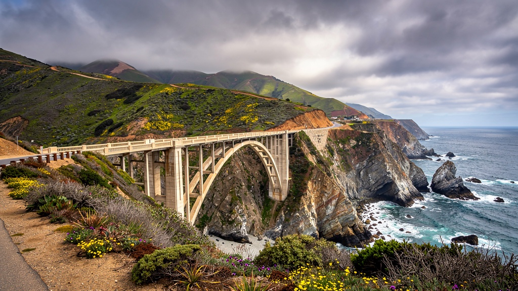
Bixby Creek Bridge is usually the first landmark visitors encounter heading south from Carmel. Completed in 1932, the graceful concrete arch spans 714 feet across a canyon 280 feet above the creek — an engineering marvel built mostly by prison labor. The small pull-off on the north side fills up fast at sunrise and golden hour; arrive early or late to avoid the crowds. The arch photograph is best from the pull-off on the south side of the bridge, looking back north.
Point Sur State Historic Park preserves a century-old lighthouse perched on a volcanic rock connected to the mainland by a sandbar. Guided tours (Saturday and Sunday only) take visitors up the 361 steps to the lighthouse itself and reveal stories of shipwrecks, whaling, and the lonely life of lighthouse keepers. The surrounding wetlands are rich in shorebirds, and grey whales pass close offshore during their December–April migration.
Andrew Molera State Park offers a rare chance to explore Big Sur on foot rather than from behind glass. The four-mile round-trip Bluffs Trail follows the clifftop above the Pacific before descending to a driftwood-strewn beach at the Big Sur River mouth — one of the few swimmable stretches in the area. Horses can be rented from the park's stables for guided beach rides.
Pfeiffer Big Sur State Park is the heart of the Big Sur community, centered on a campground tucked beneath towering coast redwoods along the Big Sur River. Day-use visitors can hike to Pfeiffer Falls (the sound of a 60-foot waterfall in a redwood grove is astonishing) and the Valley View overlook. The park's river beach is popular for summer swimming, though currents can be surprisingly strong.
McWay Falls, within Julia Pfeiffer Burns State Park, is perhaps California's most iconic photograph — an 80-foot waterfall that drops from a cliff directly onto a pristine turquoise-sand cove that is inaccessible to the public, making the experience simultaneously beautiful and tantalizingly elusive. The quarter-mile walk from the highway pullout to the overlook platform takes ten minutes and rewards visitors with one of the most stunning vistas anywhere on the coast.
Esalen Institute, perched on a cliff 45 miles south of Carmel, is famous for its clothing-optional hot springs fed by natural thermal waters. Public access is technically limited to overnight guests or participants in seminars, but a limited number of overnight "bath reservations" are sold online. Given the sheer drama of sitting in a hot mineral spring while waves crash 100 feet below, competition for these spots is fierce.
Where to Eat in Big Sur
Big Sur's handful of restaurants punch far above their weight given their remote location. Nepenthe, perched on a cliff 808 feet above the Pacific, has been serving its famous Ambrosia burger to generations of road trippers since 1949. The deck views at sunset are unparalleled. Just below Nepenthe is the Café Kevah, a more casual breakfast-and-lunch spot with equally staggering views. Big Sur Bakery, a converted farmhouse in the village, makes wood-fired pizza, house-cured meats, and artisanal pastries that attract a devoted following. Deetjen's Big Sur Inn offers candlelit dinners inside a century-old Norwegian homestead — book weeks in advance.
Where to Camp in Big Sur
Camping in Big Sur is an experience unto itself. Pfeiffer Big Sur State Park's 214-site campground books out months in advance for summer weekends — secure a reservation on Recreation.gov the moment the booking window opens six months ahead. Kirk Creek Campground, operated by the Forest Service on a cliff above the Pacific, offers spectacular ocean views but zero amenities beyond pit toilets; it operates on a first-come, first-served basis. Treebones Resort in Gorda offers glamping yurts with ocean-view hot tubs — an upscale alternative for those less inclined to carry a sleeping bag.
Historic Route 66: The Mother Road Through California
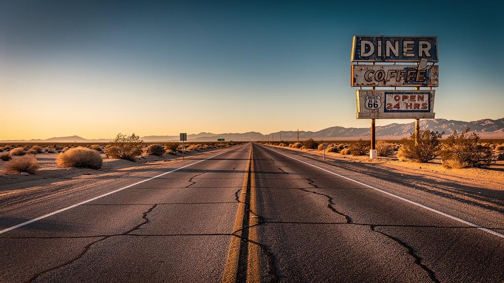
Stretching from Chicago to Santa Monica, Route 66 is perhaps the most mythologized road in American history — and California contains its final and most cinematically rewarding chapter. From Needles on the Arizona border to the Route 66 end-sign at Santa Monica Pier, California's 314-mile segment winds through the Mojave Desert, the San Gabriel Mountains, and the sprawling Los Angeles Basin, delivering a pageant of Americana that feels both achingly nostalgic and gloriously alive.
Needles to Barstow: The Raw Mojave
Most eastbound travelers entering California on Route 66 cross the Colorado River at Needles, a desert town named for the jagged peaks visible from the downtown streets. The temperature regularly exceeds 115°F in summer — John Steinbeck's Joad family in The Grapes of Wrath rejoiced at reaching Needles after crossing the desert, and today's visitors understand their relief. Summer travel should begin before sunrise.
From Needles the road rolls through the vast emptiness of the eastern Mojave, passing the ghost town of Amboy — famous for its perfectly preserved 1950s Roy's Motel and Café, now a frequently photographed landmark even in its mothballed state — and the volcanic cinder cone of Amboy Crater, reachable by a 1.5-mile hike across black lava fields. The crater last erupted roughly 10,000 years ago, but the surrounding landscape still feels unearthly enough to make you check for Martian footprints.
Barstow, the Route 66 midpoint in California, is more utilitarian than scenic, but the Route 66 Mother Road Museum (free admission, wildly enthusiastic volunteers) preserves a remarkable collection of road signage, gas station memorabilia, and Dust Bowl emigrant photographs. The nearby Casa del Desierto Harvey House — a magnificent 1911 Spanish Renaissance train station — is worth the ten-minute detour.
Victorville to San Bernardino: The Cajon Pass
From Barstow the highway enters the high desert town of Victorville, where the California Route 66 Museum occupies a beautifully restored 1918 building. South of Victorville the road climbs through the Cajon Pass, the dramatic mountain gap through the San Gabriel and San Bernardino ranges where Union Pacific and BNSF freight trains labor uphill in seemingly endless procession — railfans park at the Blue Cut viewpoint for hours. On the steep descent toward San Bernardino, roadside stands sell freshly picked oranges from the last remnants of the citrus groves that once blanketed the entire valley floor.
San Bernardino to Pasadena: The Classic Neon Strip
San Bernardino claims Route 66 history as the birthplace of McDonald's — the original 1940 Bernardino franchise site at 14th and E Street is now a museum. Heading west through Fontana, Ontario, Upland, and Rancho Cucamonga, the highway passes an almost unbroken parade of mid-century motels, diners, and drive-ins in various states of restoration and decay. The Wigwam Motel in Rialto — where guests sleep in actual concrete teepees — remains operating and is one of the most photographed buildings on the entire route.
Pasadena's stretch of Colorado Boulevard, designated a historic Route 66 corridor, is particularly rewarding: the old Foothill Boulevard alignment through Arcadia and Monrovia preserves numerous neon signs and original 1950s commercial architecture that the freeway bypassed and thus inadvertently preserved.
The Finish Line: Santa Monica Pier
Route 66 officially ends — or begins, depending on your direction — at the intersection of Olympic Boulevard and Lincoln Boulevard in Santa Monica, though tradition holds that the spirit ends at the pier itself. The Route 66 endpoint sign on the pier has been replaced so many times by souvenir hunters that the current sign is bolted with industrial hardware, but it remains a pilgrimage site for road trippers who feel the particular satisfaction of having completed one of the world's great drives. Celebrate with a corn dog and a ride on the Pacific Park Ferris wheel before dipping your toes in the Pacific.
Route 66 Travel Tips
- Season: October–April is ideal. Summer temperatures in the Mojave are genuinely dangerous; carry at least two gallons of water per person if driving in July or August.
- Maps: The EZ66 Guide for Travelers by Jerry McClanahan is the single best printed companion. Download the Historic Route 66 app for turn-by-turn directions that keep you on the old alignment rather than the parallel I-40.
- Fuel: Fill up at every opportunity between Needles and Barstow — stations are sparse and prices are high in the desert.
- Accommodation: Book early for the Wigwam Motel and the Amboy Crater area's glamping options, which sell out months in advance.
Eastern Sierra Scenic Byway: US-395 Through the High Country
If PCH is California's most famous drive and Route 66 its most storied, then US-395 through the Eastern Sierra is its most spectacular yet least-crowded grand road trip. Running north-south along the base of the Sierra Nevada escarpment from Victorville to the Nevada border, Highway 395 delivers a relentless visual spectacle: 14,000-foot peaks rising sheer from a high desert floor, volcanic tablelands, impossibly blue alpine lakes, and some of the best fly-fishing rivers in North America.
Owens Valley: The Great Basin's Hidden Gem
The Owens Valley, sandwiched between the Sierra Nevada to the west and the White and Inyo Mountains to the east, contains one of the most dramatic landscapes in North America yet attracts a fraction of the visitors drawn to Yosemite. The valley floor sits at 4,000 feet; the Sierra escarpment above it rises to 14,505-foot Mount Whitney (the highest peak in the contiguous US) in just 12 horizontal miles — a vertical relief greater than the Grand Canyon.
The town of Bishop is the valley's commercial hub and an excellent base for multi-day exploration. Its Eastern Sierra Museum charts the controversial story of the Los Angeles Aqueduct, which in the early twentieth century diverted the Owens River to the city, essentially destroying the valley's agricultural economy and draining Owens Lake to a blowing alkali flat. The Buttermilk Country bouldering area west of Bishop is internationally renowned among rock climbers.
Mono Lake, north of the Sierra crest near Lee Vining, is one of California's most otherworldly landscapes — an ancient saline lake whose shores are studded with calcium carbonate tufa towers that rise from the water like the ruins of a drowned city. The lake has no natural outlet; water evaporates and minerals concentrate over millennia. A 1994 water-rights ruling forced Los Angeles to reduce its Owens River diversions, and Mono Lake's water level has been slowly recovering ever since.
Mammoth Lakes: Year-Round Adventure Base
Mammoth Lakes is the Eastern Sierra's largest resort community and one of California's great four-season adventure destinations. In winter, Mammoth Mountain Ski Area — California's biggest ski resort, with 3,500 acres and a season that often extends into July — attracts skiers and snowboarders from across the state. In summer the mountain converts to lift-served mountain biking, while the surrounding volcanic landscape offers world-class hiking, rock climbing, and backcountry fishing.
The nearby Devils Postpile National Monument protects a remarkable formation of basalt columns — remnants of a lava flow from 100,000 years ago that cooled into near-perfect hexagonal shapes, then was planed smooth by a passing glacier. The adjacent Rainbow Falls, a 101-foot waterfall, is at its most spectacular in mid-morning when sunlight strikes the spray and creates ephemeral rainbows.
Bodie State Historic Park: America's Best Ghost Town
No Eastern Sierra road trip is complete without a detour to Bodie, a remarkably intact gold-mining ghost town preserved by the California State Parks system in a state of "arrested decay." At its 1879 peak, Bodie housed 10,000 residents, 65 saloons, and reportedly the most lawless main street in the American West. Today some 200 buildings survive — houses still contain their furniture, the general store still has goods on its shelves — giving Bodie an eerie time-capsule quality that no Hollywood set designer could replicate.
The Death Valley Loop: Desert Grandeur at Its Extreme
Death Valley National Park — the hottest, driest, and lowest national park in the United States — seems like an improbable road-trip destination until you actually visit, at which point the park's stark, violent beauty becomes addictive. The classic Death Valley loop from Las Vegas (four to five hours from Los Angeles) takes in the park's major highlights in two days, though a week would barely scratch the surface.
Zabriskie Point, reached by a short walk from a roadside parking area, offers perhaps the most otherworldly panorama in California: rippled badlands of yellow and ochre, sculpted by millions of years of erosion into ridgelines as sinuous as brushwork. The view was famously captured in Michelangelo Antonioni's 1970 film and has since been reproduced so often it risks becoming a cliché — until you stand there at dawn and feel the day's first heat rising from the golden hills, and understand that no photograph has ever truly done it justice.
Badwater Basin, at 282 feet below sea level, is the lowest point in North America. A salt flat stretching 200 square miles, it looks white and featureless from a distance but close examination reveals an intricate geometric texture of salt polygons, each hexagon a few inches across, formed as surface water evaporates and the underlying brines crystallize. Walk out onto the flat at any time except the peak of summer (June–August temperatures regularly exceed 130°F at ground level) and the silence and scale are genuinely humbling.
Artist's Drive is a nine-mile one-way loop through a canyon whose volcanic rocks contain a bewildering palette of mineral pigments: greens from copper, purples from manganese, reds and yellows from iron oxides. The display peaks in the late afternoon when raking light saturates the colors to an almost hallucinatory intensity. Mesquite Flat Sand Dunes, near Stovepipe Wells, are the park's most photogenic dunes — accessible, 100-foot-high, and particularly beautiful at sunrise when long shadows model every ripple in the sand.
Avenue of the Giants & the Redwood Highway
Northern California's Redwood Highway (US-101) becomes truly transcendent when it exits the freeway corridor and threads through Humboldt Redwoods State Park on the 31-mile Avenue of the Giants — an alternative alignment of the old highway that runs beneath the tallest trees on earth. Coast redwoods (Sequoia sempervirens) can exceed 380 feet in height and 20 feet in diameter; standing at the base of one and craning your neck to find the crown is an experience that reliably reduces grown adults to reverent silence.
The Rockefeller Forest, the world's largest old-growth coast redwood forest, protects ancient trees that were saplings when Julius Caesar walked Rome's streets. The short Bull Creek Flats Trail winds through the heart of the grove, its duff-carpeted floor thick with sword ferns and sorrel, the light filtering down in cathedral shafts. On foggy mornings — which is most mornings on the north coast — the atmosphere is almost mystical.
Continuing north on US-101 through Del Norte County, the highway enters Redwood National and State Parks, a UNESCO World Heritage Site and International Biosphere Reserve. The Tall Trees Grove here protects Hyperion, the world's tallest living tree at 380.3 feet — its exact location is kept secret by park rangers to prevent tourist trampling of its shallow root system, but a handful of permit-only ranger-led hikes bring small groups to within view of the grove each summer.
The coastal towns of Arcata (home to Humboldt State University and a thriving organic-food culture) and Crescent City (gateway to Jedediah Smith Redwoods) offer authentic north-coast hospitality far removed from the coastal tourist circuits farther south. The drive from San Francisco to Crescent City takes a full day on US-101 and rewards those who take the slow route with elk meadows at Prairie Creek Redwoods, pristine Freshwater Lagoon at the park's southern edge, and the wild, cold, unspoiled beauty of a coast that tourism has barely touched.
Planning Your California Road Trip
Choosing the Right Vehicle
For most California road trips, any reliable vehicle will suffice — the PCH, Route 66, and US-395 are all fully paved, two-lane highways easily managed in a standard sedan. However, specific trips benefit from specific vehicles:
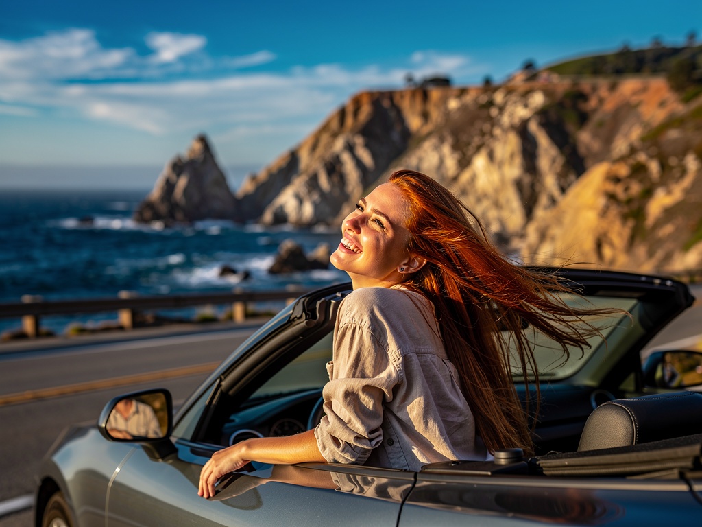
- Convertible or open-top 4WD: PCH and Big Sur are transformed by open-air driving. Hertz, Avis, and local rental companies in LA and San Francisco offer Mustang convertibles and Jeep Wranglers.
- High-clearance 4WD: Death Valley's back-country roads (Titus Canyon, Racetrack Playa) and Mojave Road are unpaved and require a high-clearance vehicle. Do not attempt in a standard rental without checking your rental agreement.
- Campervan/RV: California has exceptional campground infrastructure. Outdoorsy and RVShare list hundreds of California-based rentals; booking 2–3 months ahead is essential in summer.
- EV: California's EV charging network is excellent along the major corridors (PCH, I-5, US-101) but sparse in the Mojave and Eastern Sierra. Plan charging stops carefully using PlugShare before venturing into remote areas.
Building Your Itinerary
The most common mistake California road-trippers make is attempting too much. The state is enormous — driving from San Diego to the Oregon border on the freeway takes twelve hours without stops. On a scenic byway it takes days. A satisfying road trip requires choosing a specific corridor and exploring it deeply rather than racing between famous landmarks.
4–5 days: Fly into Los Angeles, drive PCH north to San Francisco via Big Sur. Stay 2 nights in Big Sur area campgrounds/inns. Cover approximately 500 miles.
7–10 days: Los Angeles to San Francisco via PCH, then return via US-101 and US-1 through wine country. Add Death Valley as a pre-LA or post-SF detour. Cover approximately 1,200 miles.
14+ days: Full California circuit — LA to Death Valley to Eastern Sierra to Lake Tahoe to wine country to San Francisco to Redwoods to Crescent City, returning via I-5 or US-101. Cover approximately 2,500 miles.
Accommodation Strategy
California road-trippers have three main accommodation options, each with distinct advantages:
- State and National Park campgrounds: The most immersive way to experience California's wild landscapes. Book on Recreation.gov up to six months in advance for popular sites at Big Sur, Yosemite, and Sequoia.
- Independent motels: California's surviving mid-century motels — particularly along Route 66 and US-101 — offer charm, history, and value. Apps like Roadtrippers highlight the most characterful options.
- Small inns and B&Bs: Carmel, Mendocino, Santa Barbara, and the wine country towns offer excellent small inn accommodation. Weekends book up months ahead; weekdays are more available.
Road Trip Essentials & Safety
What to Pack
California's climatic diversity means you'll experience conditions ranging from cool coastal fog to desert heat on a single road trip. Pack accordingly:
- Layered clothing (mornings at Big Sur or in the Sierra can be 40°F even in July)
- Sun protection: high-SPF sunscreen, wide-brimmed hat, polarized sunglasses
- Water: minimum 2 gallons per person for desert driving; refill at every opportunity
- Roadside emergency kit: jumper cables, reflective triangles, basic first-aid, duct tape
- Paper maps as backup (cell service disappears for hours at a time in Big Sur, Death Valley, and the Eastern Sierra)
- Reusable cooler for perishables — groceries become expensive and scarce in remote areas
- Camera with extra batteries and a polarizing filter to cut ocean glare
Wildlife Safety
California's road network passes through active wildlife habitat. Black bears are common in the Sierra; store food in bear boxes at campgrounds (California law). California condors — reintroduced from near extinction — can sometimes be spotted soaring over Big Sur's ridgelines and are a protected species. The Mojave Desert harbors Mojave rattlesnakes; watch where you step when exploring off-trail. On the north coast, rogue waves and sneaker waves claim lives every year — never turn your back on the ocean when standing on a beach or sea cliff.
Fire Awareness
California's wildfire season has expanded to year-round in many areas. Check CalFire's active fire map before departing, and monitor local news during your trip. If smoke is heavy or roads are closed due to fire activity, be prepared to alter your route. Never light campfires outside designated fire rings, and observe any current fire restriction level (currently displayed at all trailheads and park entrances).
Best Time to Drive California's Roads
🌸 Spring (Mar–May)
Ideal for PCH — wildflowers carpet Big Sur cliffs and Antelope Valley. Desert wildflower blooms in Death Valley. Mild temperatures everywhere.
☀️ Summer (Jun–Aug)
Best for the Sierra Nevada and Redwood Highway. Avoid Death Valley and Route 66 Mojave unless you depart before 7 a.m. PCH fog (June Gloom) clears by midday.
🍂 Fall (Sep–Nov)
The consensus favourite — crowds thin, temperatures moderate, October light is golden. Eastern Sierra aspens turn brilliant gold in October. Best Route 66 weather.
❄️ Winter (Dec–Feb)
Death Valley is perfect (60–70°F days). PCH can close due to landslides. Mammoth Mountain ski season peaks. Fewer tourists at coastal towns.
Whatever the season, California rewards those who venture off the freeway and onto its older, slower, more personal roads. The Pacific is always there. The redwoods are always growing. The desert is always waiting. The only question is which road you'll take first.